Mount Kilimanjaro: The Complete Guide to Africa’s Highest Peak
The Roof of Africa Awaits
There are mountains, and then there is Mount Kilimanjaro. Rising with extraordinary, almost implausible majesty from the flat plains of northern Tanzania, Kilimanjaro is not simply the highest mountain in Africa — it is one of the most iconic, most recognisable, and most emotionally powerful natural landmarks on the entire surface of the earth. Its snow-capped summit, floating above the clouds like a vision from another world, has drawn explorers, adventurers, dreamers, and ordinary people with extraordinary courage to its slopes for well over a century, and it continues to do so today with an appeal that shows no sign of diminishing.
At 5,895 metres above sea level, the Uhuru Peak on Kilimanjaro’s Kibo crater rim is the highest point in Africa and one of the celebrated Seven Summits — the highest peaks on each of the seven continents — making it a target for serious mountaineers from every corner of the globe. Yet unlike most of the Seven Summits, Kilimanjaro requires no technical climbing equipment, no ropes, no ice axes, and no prior mountaineering experience to reach its summit. It is, in the most fundamental sense, a walking mountain — extraordinarily demanding, deeply serious, and requiring thorough preparation and deep respect, but ultimately accessible to any person of reasonable fitness and genuine determination who approaches it with the patience, the humility, and the acclimatisation strategy that it demands.
To stand on the summit of Kilimanjaro at dawn, watching the shadow of the mountain stretch westward across the plains of Tanzania and Kenya as the sun rises over the Indian Ocean horizon, is an experience that people who have achieved it describe with a consistency and an emotional intensity that speaks to something far deeper than simple athletic accomplishment. It is a moment of perspective, of gratitude, of overwhelming beauty, and of quiet, hard-won personal triumph that changes people in ways they often struggle to articulate but never forget.
The Geography of Kilimanjaro: Understanding the Mountain
Three Volcanic Cones
Mount Kilimanjaro is a stratovolcano — a large, composite volcanic mountain built up from successive layers of lava, ash, and other volcanic material over millions of years. The mountain is composed of three distinct volcanic cones, each with its own character, its own history, and its own role in the dramatic topography of the massif.
Kibo is the highest and most central of the three cones, rising to 5,895 metres at Uhuru Peak and featuring the famous snow-capped summit that has made Kilimanjaro one of the most photographed mountains in the world. Kibo is considered dormant rather than extinct — there are fumaroles still active within its inner crater, suggesting that geological processes beneath the mountain continue, though no eruption has occurred in recorded history. The Kibo crater, at the summit, is approximately 2.5 kilometres in diameter and contains the inner Reusch Crater, within which the remarkable Ash Pit descends to a depth of nearly 300 metres.
Mawenzi, rising to 5,149 metres on the eastern side of the massif, is the second-highest cone and presents a dramatically jagged, heavily eroded profile that is visually striking from every angle. Mawenzi is considered extinct and is a significantly more technical climbing challenge than Kibo, with its shattered, fractured rock faces requiring genuine mountaineering skills and equipment. Most Kilimanjaro trekkers see Mawenzi as a dramatic backdrop feature rather than a climbing objective, though it is climbed by experienced alpinists who approach the mountain with the appropriate equipment and skills.
Shira, the oldest and most eroded of the three cones, forms the elevated western plateau of the massif at approximately 3,800 metres. Shira has been almost completely eroded over geological time, leaving behind a broad, relatively flat plateau that forms the landscape through which several of Kilimanjaro’s western approach routes pass. The Shira Plateau is an extraordinary environment of its own — a high-altitude moorland of haunting beauty, dotted with giant heather and senecio plants and crossed by clear, cold streams, with the dramatic profile of Kibo rising to the east like the prow of a great ship.
The Glaciers of Kilimanjaro
No discussion of Mount Kilimanjaro’s geography is complete without addressing its glaciers — those ancient, slowly retreating bodies of ice that crown the summit and give the mountain its most iconic visual characteristic. Kilimanjaro’s glaciers have existed for approximately 11,000 years, formed during a wetter, cooler period in East African climate history, and they have been retreating steadily and dramatically for at least the past century.
The data on the retreat of Kilimanjaro’s glaciers is sobering. The mountain has lost more than 85% of its glacier coverage since the first detailed survey was conducted in 1912, and the rate of retreat has accelerated significantly in recent decades. Scientists project that the remaining glaciers — currently comprising the Northern Ice Field, the Southern Ice Field, and several smaller ice bodies — may disappear entirely within the next two to three decades if current climate trends continue. The glaciers of Kilimanjaro have become one of the most visible and most discussed symbols of climate change anywhere on earth, and their gradual disappearance is a loss not only of extraordinary natural beauty but of a scientifically invaluable record of East African climate history stretching back thousands of years.
For climbers approaching the summit today, the glaciers remain one of the most breathtaking visual elements of the Kilimanjaro experience — vast, ancient walls of ice rising from the crater rim, their vertical faces catching the first light of sunrise with a blue-white brilliance that is simply unforgettable. But the awareness of their vulnerability and their transience adds a quality of particular preciousness and urgency to the experience of standing among them.
Climatic Zones of Kilimanjaro: A Journey Through Five Worlds
One of the most extraordinary aspects of climbing Mount Kilimanjaro is the remarkable ecological journey that the ascent represents. As you climb from the base to the summit, you pass through five distinct climatic and vegetation zones, each with its own temperature range, its own rainfall pattern, its own distinctive plant and animal life, and its own atmospheric character. No other single walk on earth compresses such extraordinary ecological diversity into so short a horizontal distance — in climbing Kilimanjaro, you experience something equivalent to travelling from the equatorial tropics to the Arctic in the space of a few days.
Zone 1: The Cultivation Zone (800 to 1,800 metres)
The lowest zone of the Kilimanjaro massif, the cultivation zone, occupies the fertile, well-watered lower slopes of the mountain between approximately 800 and 1,800 metres above sea level. This zone is home to the Chagga people, Tanzania’s most famous mountain-dwelling community, who have farmed the rich volcanic soils of Kilimanjaro’s lower slopes for centuries with extraordinary skill and productivity. The landscape here is one of lush, abundant cultivation — coffee and banana plantations stretch across the hillsides, interspersed with kitchen gardens, traditional homesteads, and stands of introduced eucalyptus and pine.
Temperatures in the cultivation zone are warm and pleasant, typically ranging between 20°C and 30°C throughout the year, moderated by altitude from the more intense heat of the surrounding plains. Rainfall is relatively abundant, fed by the moisture that the mountain draws from the surrounding atmosphere, and the cultivation zone enjoys two rainy seasons that mirror the pattern of the broader East African climate. Most trekkers pass through this zone quickly during the approach to the forest boundary, but it offers a fascinating and warmly human introduction to the mountain — a reminder that Kilimanjaro is not only a wilderness and a climbing challenge but a living, inhabited landscape with a deep and rich cultural history.
Zone 2: The Montane Forest Zone (1,800 to 2,800 metres)
Above the cultivation zone, the mountain is wrapped in a broad belt of montane rainforest — one of the most beautiful, most biodiverse, and most atmospherically extraordinary environments on the entire mountain. This zone, extending from approximately 1,800 to 2,800 metres, receives the highest rainfall of any zone on Kilimanjaro, as the mountain intercepts moisture-laden air masses moving inland from the Indian Ocean and forces them upward, causing them to cool and release their moisture as rain, mist, and cloud.
The forest itself is magnificent — dense, ancient, and dripping with life. Enormous trees draped in hanging mosses and lichens form a high, cathedral canopy that filters the light into a perpetual, green-tinged dimness. Giant ferns carpet the forest floor, epiphytic orchids cling to bark and branches, and the air is cool, damp, and richly perfumed with the smell of wet earth, decomposing leaves, and countless flowering plants. Temperatures in the montane forest zone range between approximately 12°C and 20°C, with the upper reaches of the zone feeling distinctly cool and misty, particularly in the afternoons when cloud regularly moves in from the south.
The forest zone is the richest zone on the mountain in terms of animal life. Blue monkeys and black-and-white colobus monkeys move through the canopy with elegant ease, their calls echoing through the trees. Elephants and buffalos range through the lower forest, though encounters with these animals on the main trekking routes are relatively rare. The birdlife is extraordinary — the forest harbours a remarkable diversity of species, including the magnificent Hartlaub’s turaco, the silvery-cheeked hornbill, and numerous species of sunbird that flash like living jewels through the green gloom.
Zone 3: The Heath and Moorland Zone (2,800 to 4,000 metres)
Above the forest, the trees thin and eventually give way entirely to one of the most visually arresting and botanically fascinating environments on earth — the heath and moorland zone of Kilimanjaro, extending from approximately 2,800 to 4,000 metres. This is the zone that most strongly captures the imagination of first-time Kilimanjaro trekkers, partly because the views begin to open up dramatically as the forest canopy disappears, and partly because of the extraordinary, almost surreal plant life that characterises the landscape.
The most iconic plants of the heath and moorland zone are the giant heathers — tree heathers that grow to heights of five metres or more, their ancient, gnarled trunks wrapped in thick mosses and their upper branches disappearing into the mist — and the extraordinary giant groundsel and giant lobelia species that are unique to the high-altitude zones of East African mountains. The giant groundsel, known scientifically as Dendrosenecio kilimanjari, can grow to heights of six metres or more and has a strikingly alien appearance — a thick, furry trunk topped with a rosette of enormous leaves, like something from a prehistoric landscape. These plants are found nowhere else on earth, and walking among them in the misty moorland light of the late afternoon creates a sensation of otherworldly beauty that stays permanently in the memory.
Temperatures in the heath and moorland zone drop significantly from those of the forest below, typically ranging between 5°C and 15°C during the day, with nights becoming noticeably cold as altitude increases toward the zone’s upper boundary. Rainfall decreases somewhat compared to the forest zone, though mist and cloud are frequent, particularly in the afternoons, and waterproof clothing is essential. The Shira Plateau, which many routes cross at around 3,800 metres, is a particularly beautiful section of this zone — a broad, open highland of haunting, windswept beauty with extraordinary views of the Kibo cone rising ahead.
Zone 4: The Alpine Desert Zone (4,000 to 5,000 metres)
Above 4,000 metres, the vegetation becomes dramatically sparser and the landscape takes on the stark, austere beauty of the alpine desert zone — a high-altitude environment of bare volcanic rock, sparse dust-adapted plants, and an atmosphere of increasing cold, aridity, and altitude that begins to test the physical and psychological resources of trekkers in earnest.
The alpine desert is a landscape of extraordinary, stripped-back beauty. The colours of the volcanic rock — rust reds, ochres, and blacks — contrast with the pale blue of the high-altitude sky and the distant white of the glaciers above, creating a visual palette of stark, dramatic intensity. Vegetation is reduced to scattered tussock grasses, small everlasting flowers, and the occasional hardy succulent — plants so deeply adapted to cold, aridity, and intense ultraviolet radiation that they seem barely alive, yet their survival in this hostile environment is a testament to the extraordinary resilience of life.
Temperatures in the alpine desert drop sharply, particularly at night. Daytime temperatures range between approximately 0°C and 10°C in the lower portions of the zone, falling to well below freezing in the upper reaches above 4,500 metres. Night-time temperatures in the high camps — Barafu Camp at 4,673 metres on the Machame Route, Kibo Hut at 4,703 metres on the Marangu Route — regularly fall to between -5°C and -15°C, and wind chill can make the effective temperature feel significantly colder. The combination of cold, aridity, and significantly reduced oxygen levels — at 4,500 metres, the air contains roughly 45% less oxygen than at sea level — makes this zone a genuine physiological challenge, and the management of altitude sickness becomes a primary concern for trekkers, their guides, and their support crews.
Zone 5: The Arctic Zone (5,000 metres to Summit)
The uppermost zone of Kilimanjaro — the arctic zone, extending from approximately 5,000 metres to the summit at 5,895 metres — is a world of rock, ice, snow, and an almost total absence of biological life that feels as remote and as alien as anything accessible on foot anywhere on earth. Here, the last vestiges of vegetation disappear entirely, replaced by bare volcanic scree, glacial ice, and the thin, cold, oxygen-depleted air of the high troposphere.
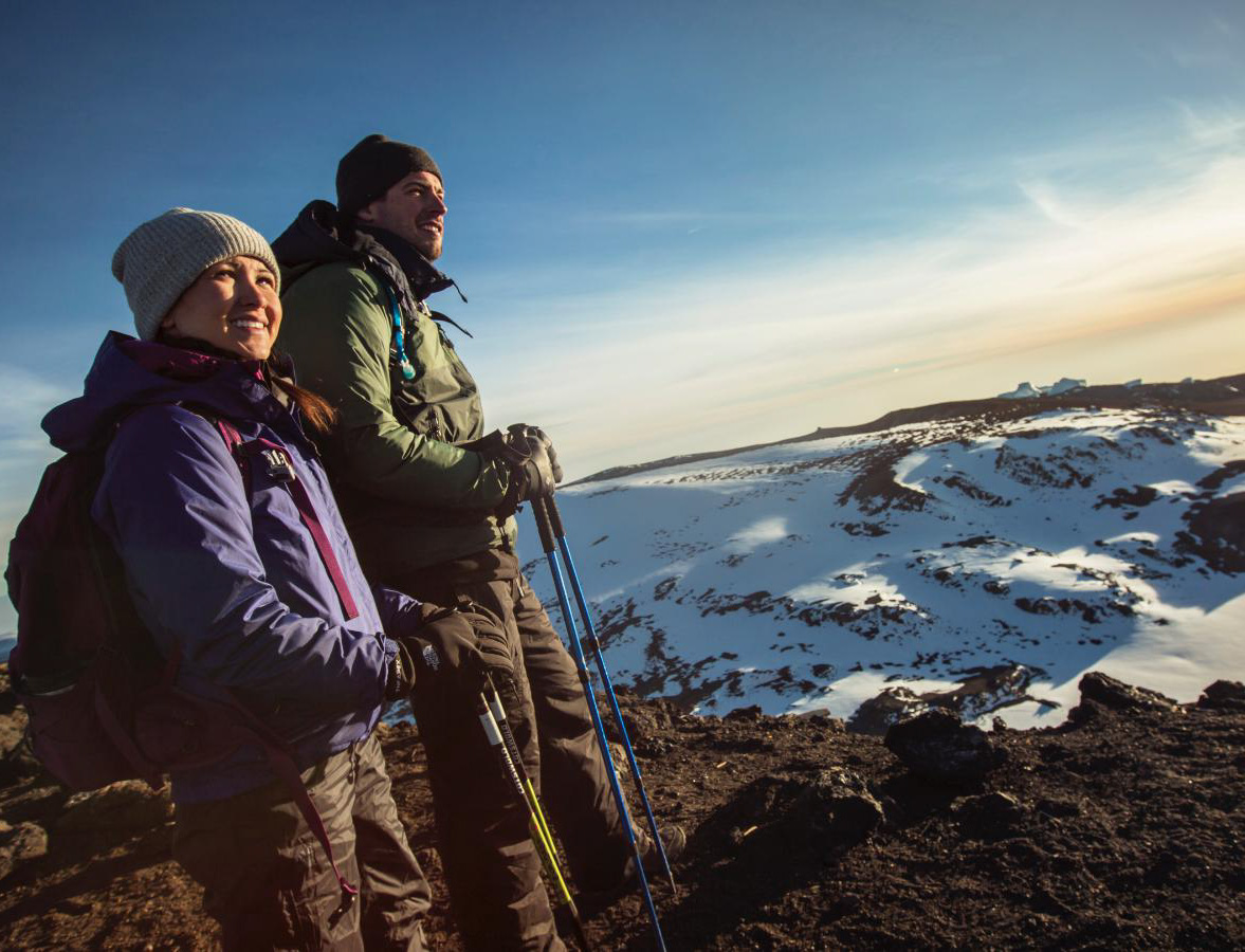
The summit push from the high camps typically begins between midnight and 2:00 in the morning, for two critical reasons. First, the frozen ground of the upper mountain is firmer and easier to walk on at night than in the afternoon, when the sun softens the scree and makes footing treacherous. Second, the goal of reaching the summit at or shortly after sunrise — to witness the extraordinary spectacle of dawn over the African continent from the Roof of Africa — is one of the most powerfully motivating and most magnificently rewarding experiences that the mountain offers.
Temperatures on the summit zone are extreme and highly variable. During the summit push in the early morning hours, temperatures regularly fall to between -15°C and -25°C, and wind speeds can increase the wind chill effect to make conditions feel equivalent to -30°C or colder. The ultraviolet radiation at summit altitude is intense, even at night, and exposed skin must be protected from both cold and UV damage. The oxygen level at 5,895 metres is approximately 49% of sea-level concentration, meaning that every breath delivers roughly half the oxygen of a breath taken at sea level — a physiological reality that makes every step on the summit cone feel enormously effortful and that makes the achievement of reaching Uhuru Peak all the more remarkable and all the more deserving of the profound pride that summit success invariably produces.
The Routes: Distance, Duration, and Difficulty
The Marangu Route: The Coca-Cola Route
The Marangu Route is Kilimanjaro’s oldest and most established trekking path, nicknamed the Coca-Cola Route because of its relative comfort and popularity. It is the only route on the mountain that offers hut accommodation rather than tenting, with three permanent huts — Mandara Hut at 2,700 metres, Horombo Hut at 3,720 metres, and Kibo Hut at 4,703 metres — providing dormitory-style sleeping facilities that make the logistical demands of the climb somewhat simpler than routes requiring full camping equipment.
The total trekking distance of the Marangu Route is approximately 64 kilometres for the round trip, as it uses the same path for both ascent and descent. The standard duration is five to six days, with the six-day option providing a critical extra acclimatisation day at Horombo Hut that significantly improves summit success rates. The route approaches the mountain from the southeastern side, passing through beautiful forest and moorland before reaching the alpine desert of the upper mountain. The gradient is relatively gentle compared to some other routes, which contributes to its reputation as the most accessible path to the summit. However, its relatively rapid ascent profile means that altitude sickness rates on the Marangu Route are among the highest of all Kilimanjaro routes, and the six-day option is strongly recommended over the five-day version.
The Machame Route: The Whiskey Route
The Machame Route is currently the most popular route on Kilimanjaro, earning its nickname — the Whiskey Route — as a counterpoint to the Marangu Route’s gentler reputation. It is a more challenging, more varied, and more scenically spectacular route than Marangu, approaching the mountain from the southwest and traversing a greater diversity of terrain and vegetation zones before reaching the summit via the dramatic Barafu Camp high on the mountain’s southeastern slopes.
The total distance of the Machame Route is approximately 49 kilometres, with the descent using a different path from the ascent — a feature that prevents the monotony of retracing one’s steps and that exposes trekkers to a greater variety of Kilimanjaro’s extraordinary landscapes. The standard duration is six to seven days, with the seven-day option providing a superior acclimatisation profile and significantly higher summit success rates. The route includes the famous Barranco Wall — a near-vertical section of approximately 300 metres that requires hands-and-feet scrambling and provides one of the most exhilarating and most photographed moments of any Kilimanjaro trek. The Machame Route’s superior acclimatisation profile and extraordinary scenic variety make it the preferred choice of many experienced trekkers and the route most widely recommended by Kilimanjaro specialists.
The Lemosho Route: The Most Scenic Path
The Lemosho Route is widely regarded by Kilimanjaro specialists and experienced trekkers as the finest route on the mountain — offering the best acclimatisation profile, the greatest scenic variety, the lowest traffic levels, and the most immersive and rewarding overall experience of any of Kilimanjaro’s established trekking paths. It approaches the mountain from the far west, crossing the magnificent Shira Plateau and offering extraordinary panoramic views that no other route can match.
The total distance of the Lemosho Route is approximately 56 to 70 kilometres depending on the specific variant taken, and the standard duration is seven to eight days — the longer duration providing the superior acclimatisation that is the route’s defining advantage and its primary contribution to the high summit success rates it consistently achieves. The route’s western approach means that trekkers spend more time at intermediate altitudes before committing to the final ascent, a physiological advantage that translates directly into lower rates of altitude sickness and higher rates of summit success. The Lemosho Route joins the Machame Route at Lava Tower and shares the final approach via Barafu Camp, but its longer, more gradual approach makes it a significantly more forgiving and more rewarding experience for the majority of trekkers.
The Rongai Route: The Northern Approach
The Rongai Route is the only route that approaches Kilimanjaro from the north, beginning near the Kenyan border and ascending through landscapes that are noticeably drier and more open than the lush southern and western approaches. The northern aspect of the mountain receives less rainfall than the southern slopes, and the vegetation and scenery of the Rongai Route have a distinctive, semi-arid character that appeals to trekkers seeking a different and less-travelled Kilimanjaro experience.
The total distance of the Rongai Route is approximately 65 kilometres for the round trip, and the standard duration is six to seven days. The route descends via the Marangu path, meaning that trekkers experience two different sides of the mountain — the dry northern slopes on the way up and the lusher, more forested southeastern slopes on the way down. The Rongai Route is considerably quieter than the Machame and Lemosho routes and offers a more solitary, more contemplative trekking experience, particularly in the lower sections where the northern forest is frequently uncrowded and deeply beautiful.
The Northern Circuit: The Ultimate Kilimanjaro Experience
The Northern Circuit is the longest, most remote, and most exclusive route on Kilimanjaro, extending the Lemosho approach into a full circumnavigation of the northern side of the mountain before the final summit push. With a total distance of approximately 90 kilometres and a standard duration of nine to ten days, the Northern Circuit offers the best acclimatisation profile of any route on the mountain, the highest summit success rates, and an experience of Kilimanjaro’s wilderness that is simply unmatched in its depth, its variety, and its extraordinary, seldom-seen beauty.
Altitude Sickness: Understanding and Managing the Greatest Challenge
Acute Mountain Sickness on Kilimanjaro
Altitude sickness — clinically known as Acute Mountain Sickness or AMS — is the single greatest challenge facing Kilimanjaro trekkers and the primary reason why a significant proportion of climbers fail to reach the summit despite being physically fit and thoroughly prepared in every other respect. At the altitudes encountered on Kilimanjaro’s upper mountain, the reduced concentration of oxygen in the air places physiological demands on the human body that training alone cannot overcome — the only effective countermeasure is time, specifically the time needed for the body to acclimatise gradually to progressively higher altitudes.
Symptoms of mild to moderate AMS include persistent headache, nausea, fatigue, loss of appetite, dizziness, and disturbed sleep — symptoms that many Kilimanjaro trekkers experience to some degree above 3,500 metres and that are manageable with rest, hydration, and a conservative pace. More serious symptoms — severe headache unrelieved by medication, vomiting, loss of coordination, confusion, or any fluid accumulation in the lungs or brain — indicate the onset of potentially life-threatening conditions that require immediate descent regardless of how close to the summit the trekker may be.
The most important principle in managing altitude on Kilimanjaro is captured in the famous climbers’ maxim: climb high, sleep low. Routes that include acclimatisation days — days on which trekkers ascend to a higher altitude before returning to sleep at a lower camp — use this principle to accelerate the acclimatisation process and significantly improve summit success rates and overall safety. Choosing a longer route, maintaining a slow and steady pace, drinking at least three to four litres of water per day, avoiding alcohol and sleeping medication, and listening carefully and honestly to your body’s signals are the foundational practices of successful altitude management on Kilimanjaro.
The Summit: Uhuru Peak at 5,895 Metres
The Moment of Achievement
The final approach to Uhuru Peak from Stella Point on the crater rim is a walk of approximately one kilometre across the crater rim, with the glaciers of the Southern Ice Field rising to the left and the vast, ancient bowl of the Kibo crater dropping away to the right. By this point, most trekkers have been walking for six to eight hours since leaving their high camp in the darkness of the previous night, their bodies operating on minimal oxygen, their legs heavy, and their minds sustained by the proximity of the goal they have been working toward for days.
And then the wooden signboard appears — the iconic, painted yellow board reading “Congratulations! You are now at Uhuru Peak, Tanzania, 5,895 m AMSL — Africa’s Highest Point — World Heritage and Wonder of Africa” — and everything else falls away. The exhaustion, the cold, the weeks of preparation, the moments of doubt on the long climb through the darkness — all of it dissolves in a moment of pure, overwhelming emotion that every person who has stood at that signboard describes with the same mixture of disbelief, gratitude, pride, and joy.
The view from the summit of Kilimanjaro on a clear morning is one of the most extraordinary panoramas available to any walker anywhere on earth. The curvature of the earth is visible on the horizon. The plains of Tanzania and Kenya stretch in every direction, impossibly vast and impossibly beautiful in the clear high-altitude light. The glaciers rise around you in walls of ancient, blue-white ice. The shadow of the mountain stretches westward for a hundred kilometres. And the sky above is a shade of deep, brilliant blue that exists only at extreme altitude — a colour so pure and so intense that it seems almost artificial, almost too beautiful to be real.
Final Thoughts: Kilimanjaro as a Life-Defining Journey
Climbing Mount Kilimanjaro is one of the most deeply rewarding physical and emotional experiences available to a human being who does not consider themselves a technical mountaineer. It demands genuine preparation, genuine respect, and genuine patience — it cannot be rushed, cannot be forced, and will not yield its summit to those who approach it arrogantly or carelessly. But to those who come to it with humility, with preparation, with a willingness to move slowly and to listen carefully to their bodies and their guides, it offers an experience of such extraordinary richness, such physical triumph, and such breathtaking beauty that it permanently and joyfully alters the way they understand what they are capable of and what the world looks like from its highest, most magnificent points.
Tanzania’s greatest mountain is waiting. The path begins at the forest boundary, winds upward through five extraordinary worlds of climate and life and landscape, and ends at a signboard on the roof of an entire continent. Every step of the way, it is worth it. Every cold morning, every breathless hour on the upper scree, every moment of doubt overcome by a quiet, determined step forward — all of it leads to a summit that will change you in ways you cannot anticipate and will not forget.
Go slowly. Drink water. Trust your guide. And climb Kilimanjaro.


%20copy%203.svg)